My friends and I decided to hike up Mt. Batolusong in Tanay, Rizal. It was actually a combination of old and new friends. I’ve only met some of my hike companions here from a connection of friends of friends. That’s a nice thing about hiking (and all other adventures), you’ll get to know different people, and sometimes you’ll get along really well right away. 🙂 I will provide Mt. Batolusong itinerary and expenses here so keep reading!

We rented a van to bring us from Cubao to Brgy. San Andres. And from here, we rode a tricycle going to the reg area. It was one bumpy ride going here. haha
This mountain has been opened for 2-3 years for hikers to climb and since then, it has been popular because of the “sea of clouds” it promises. Several celebrity hikers have already conquered this and one of those was Angel Locsin who just recently trekked up here. According to Ate Rosie (our sweeper guide), since then, hikers here just doubled.


As we arrived at the Registration Area, we immediately registered and secure guides to start as early as possible.
In our desire to be sure to see the sea of clouds, we decided to start our trek at 4:30 in the morning. FYI, it’s said that it only lasts until 9:oo a.m. So it’s advisable to do an overnight if you really want to see the sea of clouds.
It was pitch black along the trail when we began our journey, and our lead guide (Tatay Albert) only used a solar-powered lamp. Good thing I brought a flashlight, and I’m next to Tatay Albert during the start of our trek.
What is the difficulty level of batolusong?
I read on the internet, Mt. Batolusong is a beginner-friendly hike with a height of 780 MASL (Rangyas Peak), so we thought it would be easy for us. The starting trail was an easy course.
What to expect in Mt. Batolusong?
You’ll pass through a rice field, there were also some cemented parts and flat trail. So I thought, “Okay, this is definitely going to be a chill hike”. Little did I know, that was just a warm up because after 10-15mins of walking, the real challenge was revealed. An hour of continuous incline! Believe me when I said, it’s a steep slope.

For other beginners, take your time climbing this mountain. Don’t be too fast in ascending, as it will definitely exhaust your strength and energy. Remember, it’s an hour of steep course. My beginner friend (this is his mother mountain) get really exhausted and in the middle of our journey, he felt as if he was going to pass out. But, hey, he survived! YOU DEFINITELY WILL, TOO! 🙂


I myself even got a bit dizzy, can hardly breathe properly and my heart beats really fast. Didn’t have a preparation for this, and it was already 7 months since my last hike, that was why.
After that steep course, finally we saw a flat land, the Duhatan Ridge, where we can rest and take pictures….. but wait.. I was wrong. Because the crazy wild wind won’t even let us steadily hold our camera in the air. My pictures were all blurry. The wind was really strong that if you were not standing properly, it will mess up your balance.

We just stayed here for I guess 10 mins, and then we proceeded to the summit. From here, the trail is a grassland.
The place where your sleeves and face cover will come in very handy. It will be an hour or less trek going to the Mapatag Plateau where you can take pictures with these huge rocks.
This was where we took time to take pictures because the wind was a bit kinder and the sun was slowly rising, giving us a glimpse of the astounding view. The sunrise was so beautiful that I could take pictures of it from every angle! haaaay


From here, you’ll see how close you are to Rangyas Peak (summit) and it will definitely make you more excited. The surrounding was having more color by this time, thanks to Mr. Sunrise. I can take more photos now. hihi


When you pass through bamboos along the trail, that’s the time you’ll know you are almost there.


Just one short assault where you will climb on some rocks and you’re on your destination. This short assault was made difficult by the strong winds that’s why we had to hold on tight to make sure we’re not going to fall off.


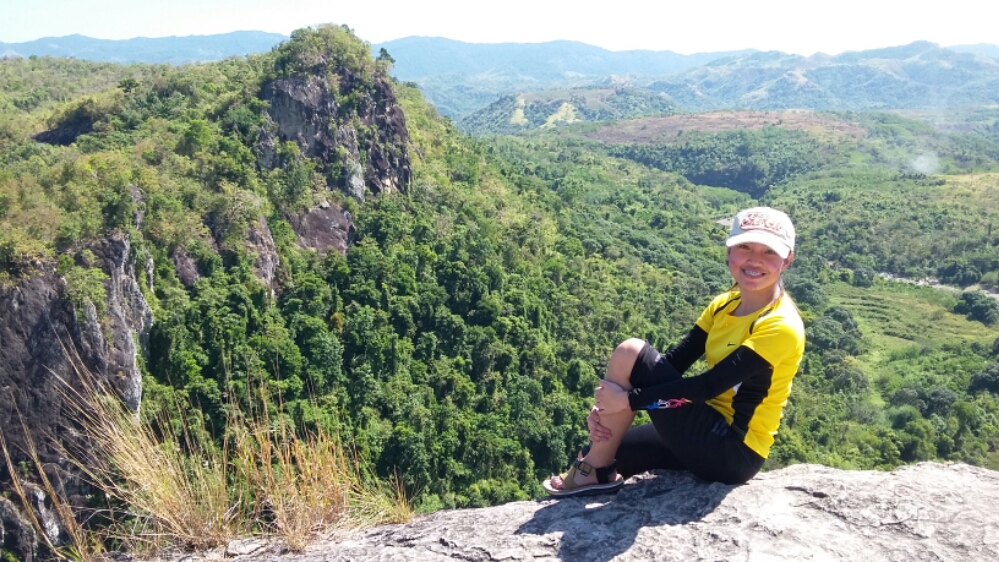
We arrived at the summit at 7:30 in the morning I think. I didn’t feel disappointed at all that there’s no sea of clouds because the view from atop was mesmerizing.


Such a great view of Rizal and Sierra Madre mountain range. A view that will make you realize that you are just a speck in this world and that there are a lot more hills to climb.

We stayed here to take pictures, rest, and eat snacks before we descended. We initially wanted to visit Kay-ibon Falls after aiming for the summit. However, it was closed for some reason.
As we were preparing for our descent, Tatay Albert mentioned that we could go side-tripping at Sangab Cave and go swimming there. Without a second thought, we hurriedly slid down the mountain to get there. LOL There’s nothing more satisfying than dipping into the cold waters after a very tiring climb, right? 🙂
Since we climbed early with pitch-black surroundings, we only saw some picture-perfect spots going down and the view with its full color.


In the middle of our descent, we decided to give our simple presents to our guides. Some stuff that we hope will be very useful for them. All our tiredness were gone because of the genuine smile on their faces. God bless you, Tatay Albert and Ate Rosie. 🙂


After 2 hours or more of descent, we finally got to see and experience the beautiful Sangab Cave with its bluish and very cold spring water (that’s why I only had a quick dip; I couldn’t handle the coldness too long). Had our lunch here too! There were restrooms in the area where you could do your thing and wash up.
We then decided to leave for home after 2 – 3 hours. From here, it will just be 15 mins walk back to the registration area.


Mt. Batolusong Expenses
PHP 150 – Bus Fare from San Pedro – Cubao – San Pedro
PHP 48 – Cubao – Cogeo – Cubao
PHP 84 – Cogeo – Brgy. San Andres – Cogeo
PHP 240 – Brgy. San Andres to Registration Area (Per tricycle; 20mins travel time)
PHP 40 – Registration Fee up to Rangyas Peak
PHP 100 – Lunch
PHP 20 – Ligo
PHP 500 – Guide Fee per group of 5
ESTIMATED TOTAL EXPENSE: PHP 602
Mt. Batolusong Itinerary
2:00 a.m. – Meet up at Farmers Cubao
4:00 a.m. – Arrive at Reg Area. (register and secure guide)
4:30 a.m. – Start Trek
6:15 a.m. – Duhatan Ridge
7:30 a.m. – Rangyas Peak (summit)
8:00 a.m. – Start Descent
10:30 a.m. – Sangab Cave (rest, swim, eat lunch, wash up, settle)
1:00 p.m. – Back to Reg. Area
1:15 p.m. – Arrive at Reg. Area (log-out)
2:30 p.m. – Travel back to Cubao
5:30 – 6:00 p.m. – Arrive at Cubao
TIPS
1. Better to wear rubber shoes. IMO, it holds better on rocks than trekking sandals. The mountain won’t be named “Batolusong” for no reason, right?
2. There are few stores along the trail but it’s still better to bring your own trail food and water. But at least, in case you’ll run out, those stores got you covered.
3. The only restroom is that at the reg area. There’s no restroom along the trail so better to do your thing before the start of the hike.
4. Wear long sleeves and pants if you have sensitive skin. Narrow trail, wild wind and tall grasses = possible skin scratches. Grasses will really get close to you.
5. If you will be hiking early in the morning, better wear thick clothes or jacket because the temperature was a bit freezing.

This was definitely one for the books! Mt. Batolusong will be an easy hike if you know your strength and will handle your pacing well.
Where to next? We’ll find out! 🙂
Have you also climbed Mt. Batolusong? How was your experience? Was it the same as ours? Share it in the comment section below, and I’d love to read it.


2 thoughts on “Mt. Batolusong Itinerary and Expenses (with Sangab Cave)”
Pingback: How to Pick Yourself Up After a Breakup - Ann Loves To Write
Pingback: Mt. Manalmon and Mt. Gola Twin Day Hike (with side trip)